.jpg)
Patraeus
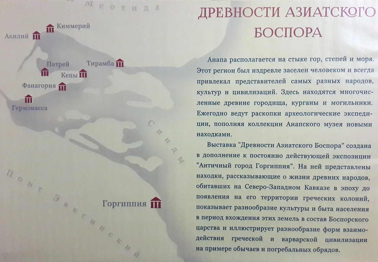
Half of this ancient city is underwater. Stand today in the flat farmland a kilometer west of the Russian village of Garkusha, and the low mound at your feet is only the Upper City of Patraeus, the part that clung to higher ground behind a defensive moat. The larger Lower City, where most people lived and worked and traded, slipped long ago beneath the shallow waters of Taman Bay, just east of the Strait of Kerch. Settlers from Miletus, the great mother-city of Greek colonization in Asia Minor, founded Patraeus around 550 BCE, and for a thousand years it was a working agricultural town at the far northeastern edge of the Greek world.
Grain at the Edge of the World
To ancient geographers, Patraeus sat at the rim of the known map. It earned mentions from Scylax of Caryanda and Hecataeus of Miletus, and later from the great Strabo, who folded it into his sprawling Geographica. But this was no city of philosophers and temples. Excavations have shown it to be, first and foremost, a farm town. The Milesians who sailed here from the Aegean did not come for glory; they came for soil. The surrounding plain was carefully divided into agricultural plots ranging from roughly three to fifteen hectares, a patchwork of ancient property lines pressed into the earth. Grain grown on these fields helped feed the wider Greek Mediterranean, shipped across the Black Sea from harbors that no longer exist. Long before the Greeks arrived, the same fertile ground had drawn a late Bronze Age farming people, so the impulse to plant here reaches back further still.
A City That Rose and Fell and Rose Again
Around 438 BCE, Patraeus joined the Delian League, the Athenian-led alliance that knit the Greek world together across the sea. Within a few decades it was absorbed instead into the Bosporan Kingdom under King Satyrus I, the regional power that would dominate this coast for centuries. Under Bosporan rule, from the fourth to the second century BCE, the city reached its height, spreading across at least fifty hectares of ground and water. Then came the long tidal rhythm of decline and revival. A small population lingered on the old ruins through the fifth to seventh centuries. Two quiet centuries of partial recovery followed, then another collapse around 1000 CE. But the land would not stay empty. From roughly 1200 CE a substantial rural settlement grew back over the ancient stones and endured all the way into the eighteenth century, farming the same drowned coastline the Milesians once claimed.
Reading the Buried Town
The modern story of Patraeus is a story of rediscovery. The site was first surveyed in 1853, when nineteenth-century antiquarians began to trace the outlines of forgotten Black Sea colonies. An initial dig came in 1928, and from 1948 onward archaeologists returned repeatedly to peel back the layers. Their finds range from ordinary to remarkable, including a lead letter written by a man named Pistos, a rare surviving scrap of personal correspondence from the ancient Greek world. Digging here is a race against the water, though. The Lower City remains submerged, its streets and houses preserved under the bay, waiting for divers and sonar rather than trowels. What you see above ground is only the surviving fraction of a town that once stretched down into what is now open water.
From the Air
Patraeus lies at 45.31°N, 36.84°E on the flat Taman Peninsula, just east of the Strait of Kerch. From altitude, orient on the broad shallow expanse of Taman Bay to the west and the ribbon of the Kerch Strait separating peninsula from Crimea; the site is low farmland with no dramatic relief. Nearest airports are Anapa-Vityazevo (URKA) and Krasnodar (URKK) to the east, with Kerch's airfield across the strait.
Nearby Stories
- Temryuk 9.2 km away
- Kerch Peninsula 17 km away
- Battle of Kerch Strait (1790) 23 km away
- Abrau Peninsula 31 km away
- Koktebel 77 km away
- Arabat Spit 96 km away
- Byriuchyi Island 143 km away
- Battle of the Kalka River 192 km away